Loading...
Expired
Posted by Admin
Date: Sep 11,2022 11:49
Date: Sep 11,2022 11:49
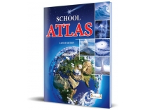
School Atlas from Inikao - School Student World Atlas Map Book English Latest Edition from Inikao(English, Paperback, International Publications, Inikao, Esha) Rs.122 @ Flipkart
-
 0
0 -
122
250
51% Off
- Favorites 0
Offers
- SBI/HSBC/BOB CC: 10% off More details
Product Description:-
Colourful Maps showing physical, political, population, timezone, climate and resources of the world. An illustrated section on astronomical informations, geographical information, scale, graticules and projection. Survey of India Approved Maps Collection., Ideal first reference atlas for young learners, travellers and teachers of ICSE, CBSE and other state boards as well as educational systems of neighbouring countries.
Free Shipping for Flipkart Plus Members or Make cart value above 500 to avoid shipping Rs. 40. Supermart Products shipping Rs. 50 Extra on order below Rs. 1200. Minimum cart value Rs. 600 required to place supermart order.
How to get this Deal Online?
- Click on Buy Now.
- Add product to cart.
- Login or register.
- Update or select shipping details.
- Pay the amount.
Highlights
- Language: English
- Binding: Paperback
- Publisher: InIkao Foundations, ESHA PUBLICATION, INTERNATIONAL PUBLICATION
- Genre: Maps, Atlas
- ISBN: 9788194198192
- Edition: Latest, 2022
- Pages: 64
Join us On Telegram Get Loot Deals Instant Alert
More Deals from flipkart


Deals of day
-
 [1-12th July] Myntra Mega Savings Sale 10 Jul,2026


Featured Stores


Most Recent post


Recent Comments
-
Samiran Chatterjee on Jiomart Quick Offer – Free Rs.100 Shopping (Check inside)
Top Coupons & Promo Codes
-

-
 Aristocrat Comet Green Medium Hard Luggage 66cm Check-in Trolley Bag with Smooth 8-Wheel Rs. 1370 - Myntra 1370 Get Code
 -
-
 Kuvings New Launch Nutri Blender PRO 2.0 Ferrari Red, Powerful 1000 W Motor, Upgraded 2 Blade Set for Wet & Dry, 2 Jars, Longest Warranty 7 Yrs, Mixer/Grinder/Smoothie Maker Rs. 3999 - Amazon 3999 Get Code
 -
